River flow velocity and discharge monitoring are critical components of hydrological and hydraulic engineering. Real-time data collection on river velocity, discharge, and water level through river monitoring systems plays a vital role in water resource management, flood prevention, hydraulic infrastructure planning, and environmental protection.
For wide or ultra-wide river channels (width >20 meters), common flow measurement methods include manual methods, cableway systems, acoustic Doppler techniques, and array-based radar wave systems. Each method has unique strengths and limitations. However, for scenarios requiring long-term online monitoring, immunity to harsh weather, operator safety, cost-effectiveness, easy installation/maintenance, non-contact operation (unaffected by sediment), and reliable performance during flood seasons, array-based radar wave flow measurement stands out as the most widely adopted and recognized solution.
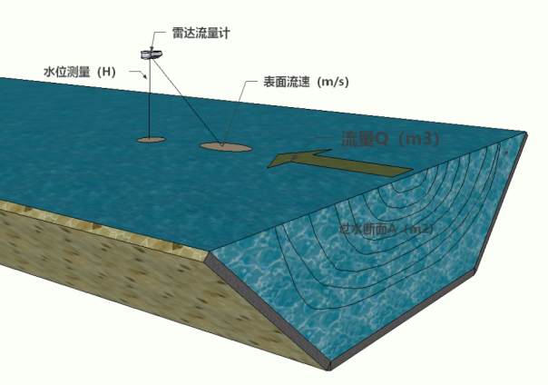
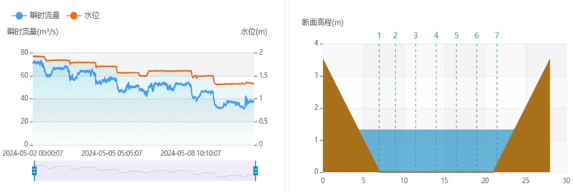
The radar-based system employs the velocity-area method for non-standard cross-sections in wide rivers. Multiple radar velocity sensors are installed at vertical lines across the river section. The discharge is calculated as:
Discharge = Average Velocity × Cross-Sectional Area
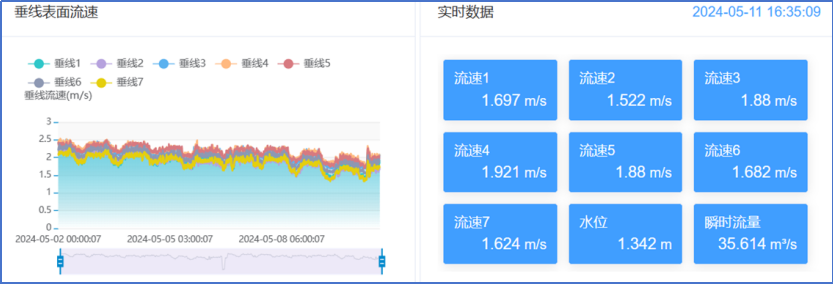
Surface Velocity Measurement: Radar velocity probes capture surface velocity, which is converted to cross-sectional average velocity using predefined hydraulic models and cross-sectional parameters.
Water Level Measurement: Radar water level probes measure depth. Combined with geometric cross-sectional data, the system automatically calculates the cross-sectional area.
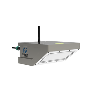
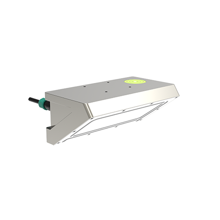
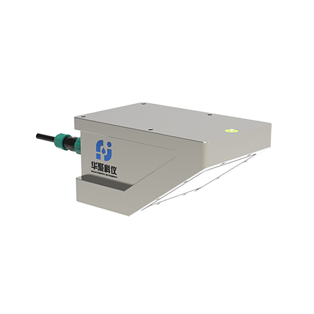
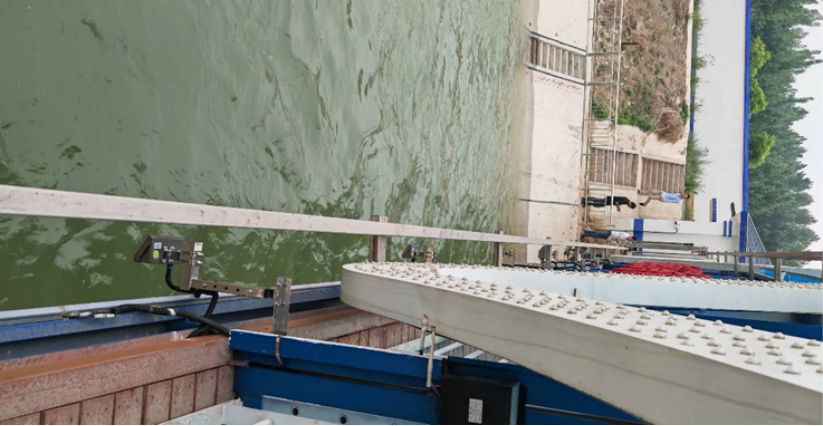
The system integrates two types of radar probes: one for surface velocity and another for water level.
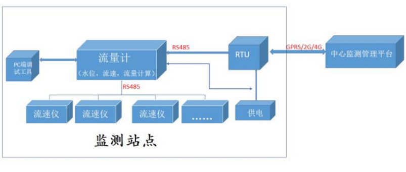
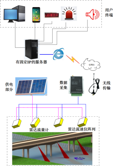
Modular Design: Multiple radar velocity sensors connect via RS485 to a central radar flow meter (host), which interfaces with a Remote Terminal Unit (RTU) for wireless data transmission to remote platforms.
Zoned Monitoring: The river cross-section is divided into zones based on bed elevation and flow patterns, with one radar velocity sensor per zone. The host can be deployed in any zone.
Non-Contact Operation: Immune to temperature, sediment, and pollutants. Combines velocity and water level data with embedded algorithms to output real-time discharge and cumulative flow.
High Reliability: Minimal maintenance, robust performance in harsh conditions.
The radar flow monitoring station operates under an unmanned, remotely managed model:
Sensors: Multiple radar velocity sensors linked via RS485 to a radar flow meter (host).
RTU Integration: Host connects to an RTU for wireless transmission of hydrological data.
Configuration: PC-based software enables parameter setup (zone division, sensor settings) and system debugging.
Auxiliary Equipment: Customizable power supply, lightning protection, and installation infrastructure based on site conditions.
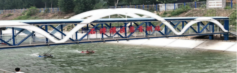
For non-contact river discharge monitoring, a "1+N" configuration is recommended:
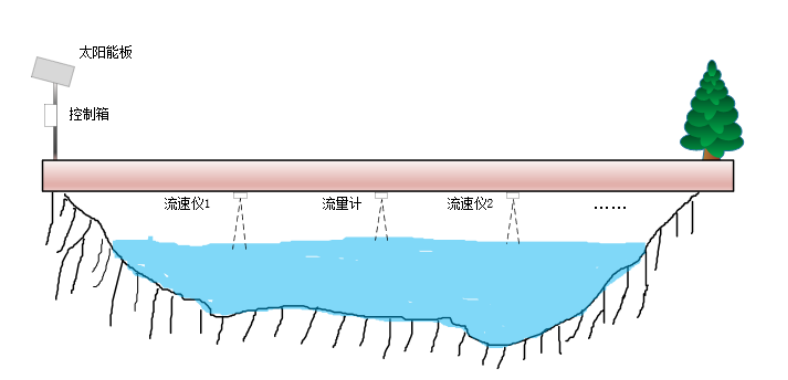
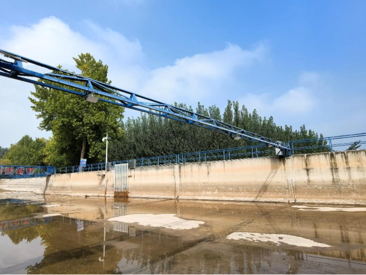
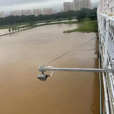
This array-based installation method addresses challenges such as uneven velocity distribution and irregular cross-sections, which can lead to significant measurement errors. By analyzing the riverbed elevation and flow patterns across the entire cross-section, the monitoring area is divided into multiple zones, with one velocity sensor deployed in each zone. The radar flow meter can be installed in any of these zones.
This approach significantly reduces measurement deviations caused by irregular river cross-sections and non-uniform velocity distribution. Additionally, construction can leverage existing bridges or cableway systems, benefiting from proven engineering practices. Therefore, the array-based installation method is highly recommended for accurate and reliable flow monitoring in wide rivers.
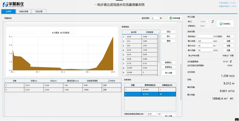
ShenZhenHuaju Scientific Instruments's Array Radar Flow Measurement Software provides:
Parameter Configuration: Zone division, device settings.
Field Debugging: Real-time data viewing, statistical analysis.
Data Management: Cross-section data import/export, user permissions.
Compatibility: Seamless integration with PC-based tools for site-specific adjustments.
The array-based radar system feeds data to centralized servers for real-time flow analysis. Multi-level monitoring centers (provincial, municipal, county) utilize GIS platforms to track water level, velocity, and discharge across all stations, enabling early flood warnings and informed decision-making.
1.Site Selection:
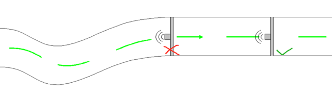
Install in straight, uniform river sections with stable flow (avoid vortices, backflows).
Avoid locations near sluice gates, reservoirs with undercurrents, culvert outlets, or windy areas.
Position probes upstream of waterfalls or steep gradients.
2.Key Considerations:
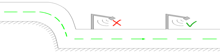
Ensure unobstructed radar signal paths.
Optimize sensor angles for accurate surface velocity detection.
Natural Wide Rivers: Multi-vertical-line array radar systems for comprehensive discharge monitoring.

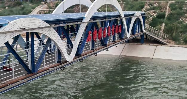
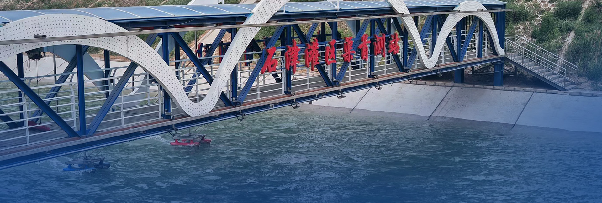
2.Irrigation Canal Headworks: Accurate flow measurement for water allocation management.
Technical Advantages:
Non-contact, maintenance-free operation.
All-weather reliability with solar/battery power options.
Scalable design for diverse river geometries.
Protocol compliance (SL651, SZY206, HJ212, MQTT).
Outcome: Enhanced hydrological monitoring efficiency, reduced operational costs, and improved flood resilience.